Mission Boulevard Linear Park, Hayward, California / Marion Brenner, courtesy of Surfacedesign
A new landscape in Hayward, California demonstrates how to reuse materials on a grand scale to save money and reduce climate impacts. Designed by landscape architects at Surfacedesign, the Mission Boulevard Linear Park — a mile-long park and walking and biking trail — repurposed asphalt, concrete, trees, soil, and even benches.
Surfacedesign saw an opportunity to try something new at the site. The existing landscape included a run-down trail with cracked asphalt, overgrown plants, and dying trees. Abandoned land on either side of the trail spanned 60 feet.
The existing trail could be expanded and enlivened by native trees and plants, new seating areas, stormwater management systems, and visual connections to the surrounding mountains.
James A. Lord, FASLA, founding partner at Surfacedesign, said reducing costs for their clients in the Hayward city government was a priority, but it wasn’t about that alone. “We thought: how can we reduce our carbon footprint? How can we reuse what was already there?”
The cracked asphalt was cut to create more sinuous pathways. Dog walkers complained that hot asphalt hurt their dogs’ feet, so they expanded the width of the trail by adding beds of decomposed granite from a local quarry.
Mission Boulevard Linear Park, Hayward, California / Marion Brenner, courtesy of Surfacedesign
Sitting areas incorporated logs from fallen trees. Over 10,000 square feet of concrete weighing 250 tons was cut out of the foundation of a deconstructed municipal building and reused as pavers.
Mission Boulevard Linear Park, Hayward, California / Marion Brenner, courtesy of SurfacedesignMission Boulevard Linear Park, Hayward, California / Marion Brenner, courtesy of Surfacedesign
The team refurbished benches from the 1980s that were collecting dust in a city boneyard. “We used the same approach as with car detailing.”
Mission Boulevard Linear Park, Hayward, California / Marion Brenner, courtesy of Surfacedesign
Unused soils from another park were brought to the site to form hills. “They visually connect to the hills beyond,” Lord said.
The team also reused municipal trees. 48 trees sourced for other city projects were planted. “The trees are all native and will soon not require irrigation,” Tyler Jones-Powell, a senior associate with the firm, said. And by rejuvenating soils, many redwoods were saved.
Mission Boulevard Linear Park, Hayward, California / Marion Brenner, courtesy of Surfacedesign
“The project is about distilling simplicity into something,” Lord said.
Surfacedesign pitched their reuse plans to the city government during the midst of the pandemic. They found a champion for their vision in Michelle Koo, the city landscape architect, and other officials. They then collaborated across multiple departments to get permissions and source city-owned materials.
“This project required tenacity but also visionary people in government who allowed it.”
While there may be a perception that reuse is bespoke and therefore expensive, the extensive reuse of materials didn’t cost more, Lord argued. In fact, the 7-acre project came in at $2 million, or $7.50 per square foot.
The cost of transporting materials was also kept low. “All the materials were from within city limits, just a few miles,” Jones-Powell said. This also resulted in far fewer greenhouse gas emissions from trucking in materials.
The project shows that old materials can provide new inspiration for designers. Their history of past use adds to their beauty. “There is a dynamic register of what the thing was,” Lord said.
Mission Boulevard Linear Park, Hayward, California / Marion Brenner, courtesy of Surfacedesign
“And reuse was the responsible thing to do,” Jones-Powell said. His advice to other landscape architects: “Don’t wipe the slate clean.”
Julie Bargmann / Photo by Barrett Doherty, courtesy of TCLF
The Cultural Landscape Foundation (TCLF) announced Julie Bargmann has won the inaugural Cornelia Hahn Oberlander International Landscape Architecture Prize for her innovative work that regenerates neglected, often polluted, communities. The biennial award of $100,000 will include two years of public engagement focused on Bargmann’s work and the state of contemporary landscape architecture. The prize is named after German-born Canadian landscape architect Cornelia Hahn Oberlander, FASLA, who passed away from complications from Covid-19 earlier this year at age 99. TCLF states that the prize is bestowed on a recipient who is “exceptionally talented, creative, courageous, and visionary” and has “a significant body of built work that exemplifies the art of landscape architecture.”
The Oberlander Prize jury said Bargmann, professor of landscape architecture at the University of Virginia and founder of D.I.R.T. (Dump It Right There) Studio, has been “a provocateur, a critical practitioner, and a public intellectual. She embodies the kind of activism required of landscape architects in an era of severe environmental challenges and persistent social inequities.” She is known for her work regenerating “contaminated, neglected, and forgotten urban and post-industrial sites.”
In her own words: “unearthing the raw ingredients of design from waste and wastelands defines my life’s work.” And this passion has driven her to “seek a larger canvas, namely, post-industrial cities and regions. There exists massive potential and sublime beauty in places that may seem, at first blush, to be trashed. Sites, neighborhoods, entire cities—they are full of energy waiting to be recognized, released, and given new form.”
TCLF states that Bargmann’s aesthetic approach is “strongly influenced by the work and writings of Robert Smithson, the American artist known for his land art installations including Spiral Jetty, and the American artist Eva Hesse. Bargmann describes her approach as ‘rigorous intuition or intuitive rigor.'”
Bargmann and D.I.R.T. are known for leading conceptual landscape designs that guide multi-disciplinary collaborations with architects, historians, engineers, hydro-geologists, artists, and the communities with which she engages.
A few of Bargmann’s key projects:
For the Vintondale Reclamation Park in Vintondale, Pennsylvania, which was completed in 2002, Bargmann collaborated with historic preservationist T. Allan Comp, hydrologist Bob Deason, and sculptor Stacy Levy on a 35-acre site in coal country designed as a “natural filtration system” that addresses polluted mine runoff. Entitled Acid Mine Drainage and Art: Testing the Waters, this “model of bioremediation” helped Bargmann win the 2001 National Design Award from the Smithsonian Cooper-Hewitt Museum. She explains that “Vintondale is the project that I feel launched D.I.R.T. and still defines its trajectory.”
Her work on the Urban Outfitters Headquarters at the U.S. Navy Yard in Philadelphia, Pennsylvania won Bargmann an ASLA Professional Award in 2014. According to TLCF, the project “became a model for the artistic and ecologically sound reuse of materials, including concrete chunks nicknamed ‘Barney and Betty Rubble,’ as well as brick, rusted metal, and other materials.” The project shows that reusing materials is not only beautiful but also reduces greenhouse gas emissions. Reusing concrete and buried train tracks saves the tons of embodied carbon emissions in these materials and avoids creating new materials that generate more emissions. A greater focus on reused and recycled landscapes is needed in the age of the climate crisis. The ASLA awards jury also noted that the “site perviousness was increased by about 800 percent.” For this project, Bargmann worked with architects at Meyer Scherer & Rockcastle, engineers with Advanced GeoServices, Corp., and environmental engineers with Blue Wing Environmental.
ASLA 2014 Professional General Design Honor Award. Urban Outfitters Headquarters at the Philadelphia Navy Yard. Philadelphia, PA. D.I.R.T. Studio / JJ TiziouASLA 2014 Professional General Design Honor Award. Urban Outfitters Headquarters at the Philadelphia Navy Yard. Philadelphia, PA. D.I.R.T. Studio / D.I.R.T. Studio
And in 2019, in Detroit, Michigan, Bargmann designed the 8,000-square-foot Core City Park in partnership with developer Philip Kafka of Prince Concepts, architect Ishtiaq Rafiuddin, and project manager Randy Pardy. The park is another ingenious model of artful reuse — almost all design elements were unearthed from the site, including “pieces of a demolished late-19th century fire station, the walls of a bank vault, and other excavated artifacts.” TCLF also calls the park an urban woodland, with tree groves that “allow visitors to break away from the city without leaving it.”
Core City Park, Detroit, MI / Photo courtesy of Prince Concepts and TCLFCore City Park, Detroit, MI / Photo courtesy of Prince Concepts and TCLF
Stay tuned for upcoming public programs organized by John Beardsley, Oberlander Prize curator at TCLF and former director of garden and landscape studies at Dumbarton Oaks.
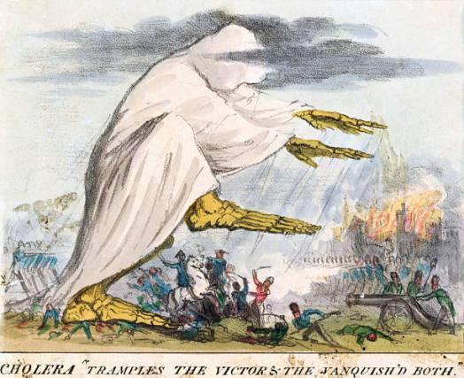
Cholera “tramples the victors & the vanquished both.” Robert Seymour. 1831. U.S. National Library of Medicine / Wikipedia, Public Domain.
19th century sanitation engineer George E. Waring, Jr. was a miasmaist. He believed in the miasma theory, which holds that toxic vapors emanated from damp soil, rotted vegetation, and pools of standing water. These toxic vapors were understood to be created by the Earth and interact with the atmosphere and cause disease in American cities.
According to Catherine Seavitt Nordenson, FASLA, a professor of landscape architecture at the Bernard & Anne Spitzer School of Architecture at the City College of New York, Waring was a “marginal figure,” but he had interesting ideas about how to “modify the climate to improve health.” In a virtual lecture hosted by the Harvard Graduate School of Design, Seavitt Nordenson said Waring was incorrect about the mechanisms for spreading disease — he didn’t understand the concept of vectors, like mosquitoes — but his drainage and sanitation solutions were “surprisingly successful.” A year into the coronavirus pandemic, it’s worth revisiting Waring’s ideas about the connections between the Earth, atmosphere, disease — and the maintenance of public spaces.
Colonel George E. Waring, Jr., full-length seated portrait, New York, NY, 1897. Photo by Hollinger & Rockey. / Library of Congress
Waring wrote numerous books, created the drainage plan for Central Park, and later became an influential sanitation commissioner of New York City. Born in Pound Ridge, New York, in 1833, he studied agricultural chemistry. In his early 20s, he wrote a book on scientific farming that explored “atmospheric and molecular matter, the interchange of Earth and air,” Seavitt Nordenson explained. He called for “mechanical cultivation to reduce water in soil” through the use of “thorough under draining, deep disturbance of the soil, and trenches.”
Because of this book, he was later hired by former U.S. presidential candidate Horace Greeley to create a drainage system for his farm in Chappaqua, New York. At his estate, Waring created an elaborate herringbone-patterned drainage system that directed water to streams, with the goal of improving the marshy soil for farming, but he would soon also use for eradicating imagined wet soil-borne disease.
Later, in 1857, Waring apprenticed as a drainage engineer with Egbert L. Viele, who had previously created a comprehensive survey and study of Manhattan, examining the marsh, meadow, and constructed lands of the island. The study included the land that would make up the future Central Park, a land that had been home to the freed Black community of Seneca Village, which was later cleared by the city government to make way for the park. Waring’s early drainage studies of Manhattan informed the many entries submitted as part of a design competition for the new Central Park.
In 1858, Waring was promoted to drainage engineer by landscape architect Frederick Law Olmsted and architect Calvert Vaux, who won the design competition for Central Park. Waring created an elaborate drainage system for the park landscape, which included low-lying wetlands. Waring had found favor with Olmsted. “Olmsted too was a miasmaist. Draining the park was framed as disease suppression.”
Men Standing on Willowdale Arch, Central Park, New York, NY, 1862. Waring is second from left. Photo by Victor Prevost. / New York Public Library
Considered the largest drainage project of his time, Waring designed a comprehensive system that directed water to constructed lakes and reservoirs. By 1859, the lower part of the park had been drained through a series of ceramic tubes buried deep into the soil that piped water directly to streams and ponds. “There was a mechanical movement to the low points,” where water would flow to.
George E. Waring, Jr., Map of Drainage System on Lower Part of the Central Park, New York, NY, 1859. / New York Historical Society.
With the onset of the Civil War in 1861, Olmsted left his position at Central Park and became executive secretary of the U.S. Sanitary Commission, where he was charged with reducing the death rate from disease for 8,000 sick and wounded soldiers. Olmsted created field hospitals in places he thought free of dangerous miasmas. Meanwhile, Waring resigned from Central Park work to become a major and lead cavalry in the Civil War.
After the Civil War and the publication of his book Drainage for Profit, Drainage for Health, Waring took up a post in Memphis, Tennessee, a city that had suffered severe epidemics of cholera and yellow fever, killing some 5,000 people in 1878 alone. While Waring didn’t understand the mosquito was a key disease vector, his plan for attacking standing water in building basements and streets had a positive effect on reducing disease. His comprehensive plan to separate the conveyance of stormwater and sewage, which was eventually implemented by the city, ended the health crisis.
Upon returning to New York City as sanitation commissioner, Waring applied his miasma theory to cleaning up the streets of the city. At the time, horses were leaving millions of pounds of manure and urine on the streets each day. Horse corpses were also left to rot. Garbage piles ran feet-deep and were cleared by ad hoc groups of unemployed.
Seavitt Nordenson thinks Waring elevated street cleaning and maintenance into a “performance,” targeting garbage as contributing to disease and declining morals. Taking a “militaristic approach,” he hired an army of sanitation workers that he dressed in all white. Nicknamed the “white wings,” they were given hand carts and brooms and also took on snow removal.
“White wings” sanitation workers, during Waring’s era / The Bowery Boys, NYC History
Waring would lead parades on horseback, with thousands of sanitation workers in army formation marching down the street. “It was a triumph of sanitation.”
Sanitation workers on parade, 1896. Organized by George Waring / Discovering NYC Twitter
After leaving the sanitation department of New York, Waring was dispatched to Havana, Cuba, by President McKinley to help solve their yellow fever epidemic. Until 1902, the U.S. had a colonial presence in Cuba, and American soldiers were dying of disease. While establishing Havana’s department of street cleaning, Waring contracted yellow fever from a mosquito. A day after his return to New York, he died, his remains quarantined on an island in New York Harbor.
Seavitt Nordenson said the legacy of miasmaists like Waring and Olmsted is the public health focus on the air — the intermixing of atmosphere and Earth. While Waring was a “brilliant failure” in terms of his scientific theories, a “great mind but incorrect,” Seavitt Nordenson also wondered: was he right?
During the pandemic, everyone has become a miasmaist to a degree, imagining the invisible droplets we know are floating in the air.
Seavitt Nordenson is currently completing a book on this topic with the University of Texas Press, with support from the Graham Foundation and the Foundation for Landscape Studies.
Take a dip in the Chicago River? Those familiar with its history might think twice.
The Chicago River has a notoriously waste-filled past. Originally, the 150-mile-long waterway was used to fuel booming industry in the Midwest city. Little attention was paid to its environmental and civic value. By the turn of the century, it was contaminated with sewage and factory waste. When a storm cause the Chicago River to overflow, it would spill into Lake Michigan, the source of the city’s drinking water, posing such an acute risk to residents’ health that in 1900 the city turned it around, reverse-engineering its flow and diverting wastewater away from Lake Michigan and out of the region to the Mississippi. The reversal was crucial to protecting thousands of Chicagoans a year from waterborne diseases like typhoid and cholera.
By 1930, after legal complaints from cities downstream, the U.S. Supreme Court ordered Chicago to address the pollution problem. Since then, efforts have been ongoing to clean up the waterway. Recently, the city has stepped up those efforts again with hopes of increase activity along and in the river, including swimming.
In 2015, Mayor Rahm Emanuel and the Metropolitan Planning Council announced the Great Rivers Chicago effort, a city-wide “visioning process” to develop a long-term plan to clean up and reintegrate into city life the three rivers of the Chicago system – the Chicago, Calumet, and Des Plaines Rivers.
The vision, released last year, lays out a series of goals that aim to make the river “inviting, productive and living” with benchmarks at 2020, 2030, and 2040. Ultimately, the city wants to draw more people to a river front that’s safer and more engaging with improve water quality.
And by 2030, they hope to make the river swimmable.
But despite reversing the Chicago River, the city’s combined sewage and stormwater system is still inundated during large storm events and can overflow into the rivers, canals, and Lake Michigan. According to The Chicago Tribune, 18.2 billion gallons of pollution entered the river last year. Chicago plans to eliminate the system’s overflows through green infrastructure and completing the Tunnel and Reservoir Plan, known as the Deep Tunnel project, which started in 1975 and the city hopes to complete by 2029.
For recreation purposes, the rivers need to achieve the “primary contact” water quality standards set for them by the U.S. Environmental Protection Agency in 2011, which would allow for safe swimming, paddling, and fishing.
Each year, 1.5 million Chicagoans and tourists flock to the popular Riverwalk, a 1.25 mile pedestrian walkway that runs from Lake Shore Drive to Lake Street on the south bank of the Chicago River in the city’s downtown. A new $108-million segment designed by the landscape architecture firm Sasaki, Ross Barney Architects, and Collins Engineers that just saw its official opening has generated even more interest in the river.
Chicago Riverwalk / SasakiChicago Riverwalk / SasakiChicago Riverwalk / Sasaki
Paddling is already happening on the river. And a floating museum, or barge-turned moveable entertainment center, which launched this week, will travel along the Chicago River through August, eventually landing at Navy Pier.
New cleanup efforts are happening right alongside all the activity. Last month, the city tested a trash skimmer to collect garbage pooling along the Riverwalk. According to The Chicago Tribune, the floating dumpster is an $11,000 pilot program running through the fall that “sucks in the bacteria-laden water and uses a mesh screen to catch oil pollutants and floating garbage.”
Some residents are ready to take the plunge now, but getting much of the public past the initial “ew factor” of swimming in infamously-polluted waters may take time. Regardless, beyond swimmable urban waterways, this aspiring scheme could offer a unique way of looking at a role of a river can play in connecting a city.
To dredge simply means to scoop up sediment, often underwater, and move it to another location. While this process is often associated with moving contaminated soils to a place where they can be safely capped, today, dredging is also increasingly about harnessing natural processes to create new landforms and ecological systems. New “dredge landscapes,” designed systems, offer opportunities for ecological restoration, said Brett Milligan, ASLA, Dredge Research Collaborative, at the ASLA 2014 Annual Meeting in Denver.
Sediment is dynamic and dramatically differs from place to place. Studying the natural flow of sediment in rivers and deltas, we can begin to understand how the movement of sediment can be “choreographed” to achieve ecological goals. However, given sediment flow happens within complex ecosystems impacted by human activities, like the deepening of channels for large ships, using dredge to create new landscapes is a highly complicated process.
As an example, Milligan pointed to efforts to dredge sediment into new landforms that can support wetlands in Jamaica Bay in New York. At current rates, “the wetlands will totally disappear in 10 years. Water regimes have changed due to stormwater runoff and deeper shipping channels.” While efforts are underway to rebuild the low-lying islands that can support wetlands in the bay, he asked how dredge can be used to restore a natural environment “where everything has changed?”
According to Hugh Roberts, Arcadis, we must “design with nature” when dredging, and a changing nature at that. Coastal land loss plus sea level rise means using dredged sediment to create wetland habitat is incredibly complex, hence the need for his job, numeric modeling lead. Wetlands require multiple flushings of water per day and they only exist at sea level, so there are “narrower number of places where they can survive. It’s a fine balance.”
In the Mississippi River delta, Roberts has been working on the White Delta diversion project, which aims to create the most efficient interventions for spreading out sediment in the widest possible fan from the river into the delta. Flow paths are dredged to enable the reconstitution of sediment far into the delta plains. All of this is part of an effort to undo the built system of containing the river, which looks like “a plumbing diagram,” in favor of letting the river flow and deposit sediment where it’s most needed, ecologically.
Roberts also pointed to the innovative Sand Engine project in the Netherlands as a great example of how dredging can work with nature. The Dutch have created a “changing land form that distributes sand along the Dutch coast.” They have placed large “nourishment mounds.” Nature then “spreads out the sand where it needs to.”
This process is the opposite of the conventional approach of pumping sand directly onto eroding beaches, an approach often called botoxing beaches. Like botox, this pumping approach only works for so long before the beach needs to be re-sanded.
The Sand Engine, Roberts says, is about “increasing resilience through nature.” Models, like the ones he creates, can help nature optimize its efforts. Today, one can see the Sand Engine has actually resulted in “natural dune formations” and the return of endangered plant species.
Dutch Sand Engine / Topos Magazine
Milligan said up to 45 gigatons of earth is dredged per year, about 30 tons per person in the U.S. According to engineer and dredger Chris Dols, Great Lakes Dredge and Dock, there are a number of different dredging technologies. There’s the cutter suction dredge, which turns mud underwater into a slurry then moved through massive hydraulic pumps. Then there’s hopper dredging, which involves using a mobile dredging vessels that vacuums up material then stores it within the boat only to be sprayed or pumped to other locations. Both can be used to support restoring ecosystems.
Sean Burkholder, ASLA, a landscape architecture professor at University at Buffalo, wants landscape architects to see dredging as a real design opportunity. Today, in the Great Lakes region, only 25 percent of sediment is reused; the rest is dumped on land or sent out to sea. Instead of treating contaminated sediment as merely waste that needs to be moved and capped, contaminants can be separated out, leaving material to create new dredge landscapes. “We can use this material more creatively in our own work.”
Also, existing dredged landscapes can become environmental education opportunities. These landscapes are typically near cities. “We can create access and interpretation for legacy sites.”
For those interested in learning more about dredge landscapes, Milligan organizes DredgeFest every year.